
National
Hurricane Matthew’s U.S. Impacts: Life-Threatening Storm Surge, Damaging Winds, Flooding Rainfall
[WEATHER.COM]
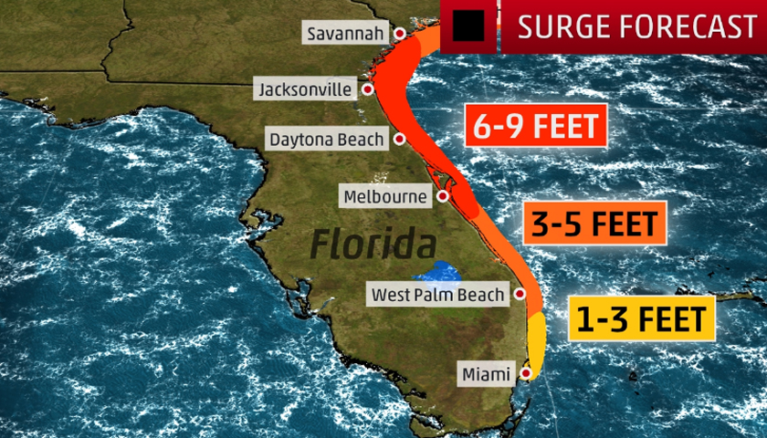
Hurricane Matthew is set to deliver a devastating blow to eastern Florida starting Thursday night, and then will hammer areas farther north up the coast in Georgia and the Carolinas Friday into the weekend.
An important point to make is that landfall does NOT need to take place for the worst impacts to come ashore. The strongest winds and most drilling surge will come to the coast in the eyewall, which surrounds the eye. Landfall occurs when the calmest portion of the eye, or the center, comes ashore. Hurricane conditions will come ashore even if the center stays 20 to 30 miles offshore.
The severe impacts from this hurricane could lead to some locations being uninhabitable for weeks or months, the National Weather Service says.
Here is the latest on what we know about Matthew right now in terms of U.S. impacts.
As far as timing for any impacts along the Southeast coast, here is a general overview. The NHC forecast calls for Matthew to be a dangerous Category 4 hurricane near the coast of Florida, capable of producing devastating impacts.
Florida Peninsula (particularly eastern Florida): Late day Thursday-Friday, possibly lingering into early Saturday in northeast Florida.
Southeast Georgia: Friday-Saturday.
Eastern Carolinas: Later Friday-Saturday, possibly continuing into Sunday.
Finish reading the story at The Weather Channel.